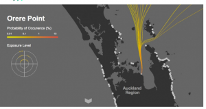
There are many aspects to protecting surfbreaks, from sand movement, to man-made development, to water quality and access to the break. But one of the aspects that often is overlooked is the Swell Corridor, mainly because it extends away from the land out to sea.
Some fantastic work has been done as part of the Waikato Regional and Auckland Council Coastal Policy reviews (the Regional Coastal Policy Statements) on the swell corridors.
Here is an interactive map showing the swell corridors for most of the surfbreaks in those regions Swell Corridors
This work was undertaken by a small ocean consultancy based in Ragan.
from Dumpark’s web page
With the inclusion of “Surf Breaks” in the New Zealand Coastal Policy Statement (NZCPS 2010), methodologies have been developed as tools for “identifying and assessing” (Policy 15c) these “natural land forms” (Policy 13 (2c)) in order to assist Regional Councils in Planning and Management of the Coastal Environment.
Dumpark have developed a robust methodology for identifying a surf break swell corridor, using a wave propagation model and a filtering algorithm.
Assuming a constant bathymetry, the wave characteristics at a particular surf break are a function of the height, period and direction of the incident offshore swell. The filtering algorithm identifies the possible combinations of offshore swell periods and directions that can propagate to a surf break.
Vector spatial data (polyline arc of swell prorogation) is extracted from the model outputs where the unitary ratio of significant wave height over the offshore wave height is above zero. Attached as attributes to each swell polyline arc are an unitary ratio of significant wave height at a particular point over the offshore wave height and a historically joint probability calculation of swell period and direction from a 15 year hindcast data set of offshore swell.


